Datei:Prague districts.svg

Größe der PNG-Vorschau dieser SVG-Datei: 800 × 600 Pixel. Weitere Auflésungan: 320 × 240 Pixel | 640 × 480 Pixel | 1.024 × 768 Pixel | 1.280 × 960 Pixel | 2.560 × 1.920 Pixel.
Version in hechara Auflesung (SVG-Datei, Basisgress: 1.024 × 768 Pixl, Dateigress: 1,09 MB)
Bschreiwung
| Bschreiwung |
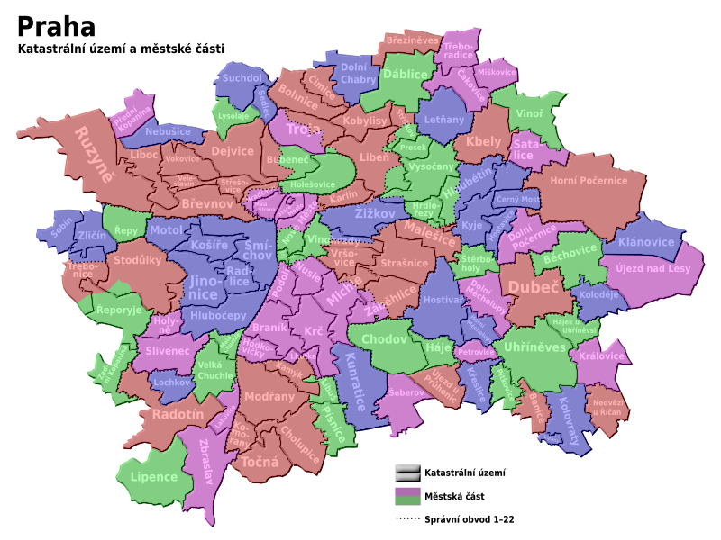
English: Maps of Prague cadastre and administratice districts
Čeština: Mapa pražských katastrálních území a městských částí |
| Daatum | |
| Quejn | Eigenes Werk |
| Urhéwer | Kubiik |
| Aundre Versióner | Derivative works of this file: Prague districts en.svg |
Lizenz
Diese Datei ist unter der Creative-Commons-Lizenz „Namensnennung – Weitergabe unter gleichen Bedingungen 3.0 nicht portiert“ lizenziert.
- Dieses Werk darf von dir
- vabroatt wern – vafüfötigt, vabroatt und éffantlich zuegénglich gmocht wern.
- neu zusammengestellt werden – abgewandelt und bearbeitet werden
- Zu den folgenden Bedingungen:
- Nåmansnénnung – Du musst angemessene Urheber- und Rechteangaben machen, einen Link zur Lizenz beifügen und angeben, ob Änderungen vorgenommen wurden. Diese Angaben dürfen in jeder angemessenen Art und Weise gemacht werden, allerdings nicht so, dass der Eindruck entsteht, der Lizenzgeber unterstütze gerade dich oder deine Nutzung besonders.
- Weidergob unter gleiche Bedingungan – Wenn du das Material wiedermischst, transformierst oder darauf aufbaust, musst du deine Beiträge unter der gleichen oder einer kompatiblen Lizenz wie das Original verbreiten.

|
Es ist erlaubt, die Datei unter den Bedingungen der GNU-Lizenz für freie Dokumentation, Version 1.2 oder einer späteren Version, veröffentlicht von der Free Software Foundation, zu kopieren, zu verbreiten und/oder zu modifizieren; es gibt keine unveränderlichen Abschnitte, keinen vorderen und keinen hinteren Umschlagtext.
Der vollständige Text der Lizenz ist im Kapitel GNU-Lizenz für freie Dokumentation verfügbar. |
Dateiversiona
Wensd auf an Zeitpunkt klickst, nacha konst a friaane Version lodn.
| Version vom | Vorschaubuidl | Dimensióna | Nutzer | Kommentar | |
|---|---|---|---|---|---|
| aktuell | 20:29, 8. Jun. 2021 | | 1.024 × 768 (1,09 MB) | Martin Tauchman | File uploaded using svgtranslate tool (https://svgtranslate.toolforge.org/). Added translation for cs. |
| 20:24, 8. Jun. 2021 |  | 1.024 × 768 (1,08 MB) | Martin Tauchman | File uploaded using svgtranslate tool (https://svgtranslate.toolforge.org/). Added translation for de. | |
| 14:09, 9. Mai 2009 |  | 1.024 × 768 (1.002 KB) | Kubiik | Troja is separated part | |
| 11:37, 9. Mer. 2009 |  | 1.024 × 768 (1.002 KB) | Kubiik | More accurate and shadow borders | |
| 14:37, 5. Few. 2009 |  | 1.313 × 990 (884 KB) | Kubiik | {{Information |Description={{en|1=Maps of Prague cadastre and administratice districts}} {{cs|1=Mapa pražských katastrálních území a městských částí}} |Source=Own work by uploader |Author=Kubiik |Date=2009-02-01 |Permission= |ot |
Dateivawendung
Seitn wo de Datei nutzn:
Globale Dateinutzung
D'noochéfóiganden åndern Wikis vawénden dé Datei:
- Vawendung af bs.wikipedia.org
- Vawendung af cs.wikipedia.org
- Vawendung af cs.wikiversity.org
- Vawendung af de.wikipedia.org
- Vawendung af it.wikipedia.org
- Vawendung af ru.wikipedia.org