Datei:C77190s1 Ant.Map Ross Island.jpg
Gress dea Voaschau: 800 × 508 Pixel Weitere Auflésungan: 320 × 203 Pixel | 640 × 406 Pixel | 1.024 × 650 Pixel | 1.280 × 813 Pixel | 2.560 × 1.625 Pixel | 5.118 × 3.249 Pixel.
Version in hechara Auflesung (5.118 × 3.249 Pixel, Dateigress: 1,95 MB, MIME-Typ: image/jpeg)
| Bschreiwung |
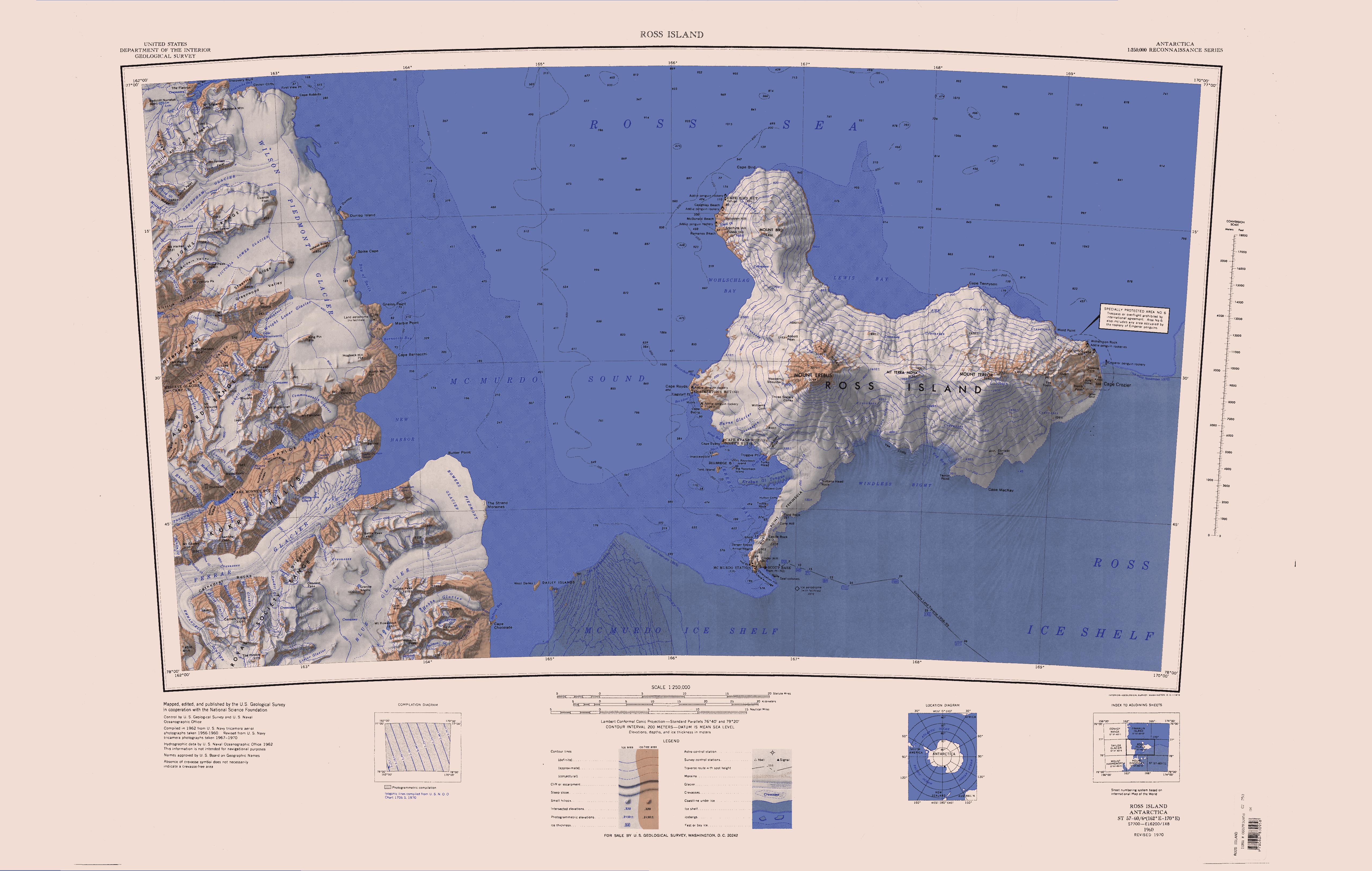
English: Map of Antarctica by the United States Antarctic Resource Center of the US Geological Society. |
| Quejn | USGS |
| Urhéwer | USGS |
| Aundre Versióner | File:Ross Island Topographic Map USGS.png : Higher quality PNG version |
Dieses Bild ist gemeinfrei (public domain), weil es Materialien beeinhaltet, die ursprünglich vom United States Geological Survey, einer Behörde des Innenministeriums der Vereinigten Staaten, stammen. Weitere Informationen finden Sie in den Urheberrechtsbestimmungen des USGS
|
Dateiversiona
Wensd auf an Zeitpunkt klickst, nacha konst a friaane Version lodn.
| Version vom | Vorschaubuidl | Dimensióna | Nutzer | Kommentar | |
|---|---|---|---|---|---|
| aktuell | 14:01, 15. Apr. 2005 | | 5.118 × 3.249 (1,95 MB) | Achim Raschka | Map of Antarctica by the United States Antarctic Ressource Center of the US Geological Society. {{PD-US}} Copyrights and Trademarks USGS-authored or produced data and information are in the public domain. While the content of most USGS web pages is in th |
Dateivawendung
Seitn wo de Datei nutzn:
Globale Dateinutzung
D'noochéfóiganden åndern Wikis vawénden dé Datei:
- Vawendung af ceb.wikipedia.org
- Vawendung af de.wikipedia.org
- Meserve-Gletscher
- Antarktische Trockentäler
- Tschadsee (Antarktika)
- Dailey Islands
- Marble Point
- Kap Roberts
- Wilson-Piedmont-Gletscher
- Kap Bernacchi
- Bernacchi-Bucht
- Bowers-Piedmont-Gletscher
- Blue Glacier
- Denton Hills
- Staeffler Ridge
- Matterhorn (Viktorialand)
- Lacroix-Gletscher
- Matterhorn-Gletscher
- Debenham-Gletscher
- Gonville and Caius Range
- Arnold Cove
- Gneiss Point
- Redcliff-Nunatak
- Borns-Gletscher
- Mount Coates (Viktorialand)
- Briggs Hill
- Descent-Pass
- Brodie Ponds
- Kuechle Island
- West Dailey Island
- Vawendung af en.wikipedia.org
- Royal Society Range
- Koettlitz Glacier
- Ferrar Glacier
- Taylor Glacier
- Wright Valley
- Asgard Range
- Mount Lister
- Taylor Valley
- Victoria Valley
- Mount Newall
- Newall Glacier
- Wilson Piedmont Glacier
- Bettle Peak
- Briggs Hill
- Cathedral Rocks
- Olympus Range
- Denton Hills
- Kukri Hills
- Mount Falconer
- Flint Ridge
- Garwood Valley
Weitere globale Verwendungen dieser Datei anschauen.