Datei:Caucasus 300 map de.svg

Größe der PNG-Vorschau dieser SVG-Datei: 771 × 599 Pixel. Weitere Auflésungan: 309 × 240 Pixel | 618 × 480 Pixel | 988 × 768 Pixel | 1.280 × 995 Pixel | 2.560 × 1.990 Pixel | 1.155 × 898 Pixel.
Version in hechara Auflesung (SVG-Datei, Basisgress: 1.155 × 898 Pixl, Dateigress: 4,44 MB)
Bschreiwung
| Bschreiwung |
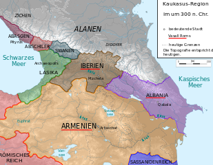
Deutsch: Kaukasus-Region um 300 n. Chr.
Quellen sind File:Geor_earliest_2A.jpg , Putzger historischer Weltatlas Ausgabe 2005, Heinz Fähnrich: Geschichte Georgiens von den Anfängen bis zur Mongolenherrschaft. Shaker, Aachen 1993, ISBN 3-86111-683-9., http://www.armenica.org/cgi-bin/armenica.cgi?178711717323498=1=3==Armenia==1=3=AAA |
||
| Daatum | |||
| Quejn | work by uploader, derivate of File:Caucasus_topographic_map-fr.svg | ||
| Urhéwer | Don-kun | ||
| Gnémigung (Weidernutzung voh derer Daatei) |
Diese Datei ist unter der Creative-Commons-Lizenz „Namensnennung – Weitergabe unter gleichen Bedingungen 3.0 nicht portiert“ lizenziert.
|

Dateiversiona
Wensd auf an Zeitpunkt klickst, nacha konst a friaane Version lodn.
| Version vom | Vorschaubuidl | Dimensióna | Nutzer | Kommentar | |
|---|---|---|---|---|---|
| aktuell | 21:41, 17. Aug. 2009 | | 1.155 × 898 (4,44 MB) | Don-kun | false version ;) |
| 21:37, 17. Aug. 2009 |  | 1.155 × 898 (4,46 MB) | Don-kun | following Fähnrich, Iberia lost southern territories at the end of the rule of Amasasp III (260-265) | |
| 23:42, 8. Aug. 2009 |  | 1.155 × 898 (4,44 MB) | Don-kun | colors like the others, corrections following armenica.org and Putzger and others about Roman conquest in Assyria in that time. | |
| 23:37, 29. Mer. 2009 |  | 1.155 × 898 (4,49 MB) | Don-kun | {{Information |Description={{de|1=Kaukasus-Region um 300 n. Chr. Quellen sind http://commons.wikimedia.org/wiki/File:Geor_earliest_2A.jpg , Putzger historischer Weltatlas Ausgabe 2005, Heinz Fähnrich: ''Geschichte Georgiens von den Anfängen bis zur Mo |
Dateivawendung
Seitn wo de Datei nutzn:
Globale Dateinutzung
D'noochéfóiganden åndern Wikis vawénden dé Datei:
- Vawendung af de.wikipedia.org
- Vawendung af pl.wikipedia.org