Datei:Empire of the Kökturks.png

Gress dea Voaschau: 800 × 499 Pixel Weitere Auflésungan: 320 × 200 Pixel | 640 × 399 Pixel | 1.024 × 638 Pixel | 1.280 × 798 Pixel | 1.745 × 1.088 Pixel.
Version in hechara Auflesung (1.745 × 1.088 Pixel, Dateigress: 2,56 MB, MIME-Typ: image/png)
Bschreiwung
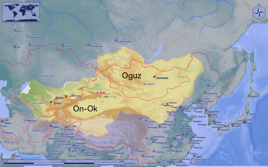
| Bschreiwung | This map shows the kingdom of Kökturks after the division of the kingdom in 552. The grey area shows the area of On-Ok or the western Kökturks. The white area shows the area of the eastern Kökturk. This area was still in the sixth Century a Chinese protectorate. 745 the Kökturks were part of the Uyghur empire. After 840 Kökturks and the Uyghurs were conquered by the Kyrgyz. The source of this map: "Der große Atlas Weltgeschichte", Orbis Verlag 1990, ISBN 3-572-04755-2, P. 47 & 51 |
| Daatum | |
| Quejn | Eigenes Werk |
| Urhéwer | Hardcore-Mike |
Lizenz
Diese Datei ist unter der Creative-Commons-Lizenz „Namensnennung 3.0 nicht portiert“ lizenziert.
- Dieses Werk darf von dir
- vabroatt wern – vafüfötigt, vabroatt und éffantlich zuegénglich gmocht wern.
- neu zusammengestellt werden – abgewandelt und bearbeitet werden
- Zu den folgenden Bedingungen:
- Nåmansnénnung – Du musst angemessene Urheber- und Rechteangaben machen, einen Link zur Lizenz beifügen und angeben, ob Änderungen vorgenommen wurden. Diese Angaben dürfen in jeder angemessenen Art und Weise gemacht werden, allerdings nicht so, dass der Eindruck entsteht, der Lizenzgeber unterstütze gerade dich oder deine Nutzung besonders.
Dateiversiona
Wensd auf an Zeitpunkt klickst, nacha konst a friaane Version lodn.
| Version vom | Vorschaubuidl | Dimensióna | Nutzer | Kommentar | |
|---|---|---|---|---|---|
| aktuell | 12:16, 10. Aug. 2020 | | 1.745 × 1.088 (2,56 MB) | MicBy67 | Leichte Überarbeitung der Grenzverläufe, Änderung des westl. Teilreiches in "On-Ok" |
| 02:48, 26. Jul. 2020 |  | 1.745 × 1.088 (2,56 MB) | MicBy67 | Überarbeitung | |
| 21:59, 1. Nóv. 2012 |  | 1.056 × 850 (1,17 MB) | MicBy67 | Map fault repaired | |
| 20:17, 1. Nóv. 2012 |  | 1.056 × 850 (1,17 MB) | MicBy67 | {{Information |Description=This map shows the kingdom of Kökturks after the division of the kingdom in 552. The grey area shows the area of On-Ok or the western Kökturks. The white area shows the area of the eastern Kökturk. This area was still in t... |
Dateivawendung
Seitn wo de Datei nutzn:
Globale Dateinutzung
D'noochéfóiganden åndern Wikis vawénden dé Datei:
- Vawendung af ast.wikipedia.org
- Vawendung af cs.wikipedia.org
- Vawendung af de.wikipedia.org
- Vawendung af en.wikipedia.org
- Vawendung af es.wikipedia.org
- Vawendung af fr.wikipedia.org
- Vawendung af mn.wikipedia.org
- Vawendung af pnb.wikipedia.org
- Vawendung af sl.wikipedia.org
- Vawendung af zh.wikipedia.org