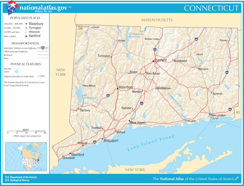
Datei:Map of Connecticut NA.png

Gress dea Voaschau: 784 × 600 Pixel Weitere Auflésungan: 314 × 240 Pixel | 627 × 480 Pixel | 1.004 × 768 Pixel | 1.280 × 980 Pixel | 2.015 × 1.542 Pixel.
Version in hechara Auflesung (2.015 × 1.542 Pixel, Dateigress: 1,86 MB, MIME-Typ: image/png)
Bschreiwung
| Bschreiwung | |
| Daatum | |
| Quejn | |
| Urhéwer | National Atlas of the United States |
| Gnémigung (Weidernutzung voh derer Daatei) |
Public domain |
Lizenz
Diese Karte stammt aus einer Ausgabe des National Atlas of the United States. Wie fast alle Arbeiten der Regierung der Vereinigten Staaten sind Arbeiten des National Atlas in den USA gemeinfrei.
Online-Zugang: NationalAtlas.gov | Gedruckte Ausgabe von 1970: Library of Congress, Perry-Castañeda Library
|
Dateiversiona
Wensd auf an Zeitpunkt klickst, nacha konst a friaane Version lodn.
| Version vom | Vorschaubuidl | Dimensióna | Nutzer | Kommentar | |
|---|---|---|---|---|---|
| aktuell | 00:18, 6. Dez. 2016 | | 2.015 × 1.542 (1,86 MB) | Ras67 | cropped |
| 22:26, 14. Aug. 2006 |  | 2.122 × 1.640 (1,96 MB) | Huebi~commonswiki | {{Information| |Description=Map of Connecticut |Source=[http://www.nationalatlas.gov National Atlas] }} Category:Maps of the United States Category:Maps of Connecticut {{PD-USGov-Atlas}} |
Dateivawendung
Seitn wo de Datei nutzn:
Globale Dateinutzung
D'noochéfóiganden åndern Wikis vawénden dé Datei:
- Vawendung af da.wikipedia.org
- Vawendung af de.wikipedia.org
- Vawendung af en.wikipedia.org
- Vawendung af hsb.wikipedia.org
- Vawendung af hu.wikipedia.org
- Vawendung af mr.wikipedia.org
- Vawendung af sw.wikipedia.org
- Vawendung af zea.wikipedia.org