Datei:Map of the Viceroyalty of Peru.svg

Größe der PNG-Vorschau dieser SVG-Datei: 800 × 407 Pixel. Weitere Auflésungan: 320 × 163 Pixel | 640 × 325 Pixel | 1.024 × 520 Pixel | 1.280 × 650 Pixel | 2.560 × 1.301 Pixel | 3.121 × 1.586 Pixel.
Version in hechara Auflesung (SVG-Datei, Basisgress: 3.121 × 1.586 Pixl, Dateigress: 1,67 MB)
Bschreiwung
| Bschreiwung |
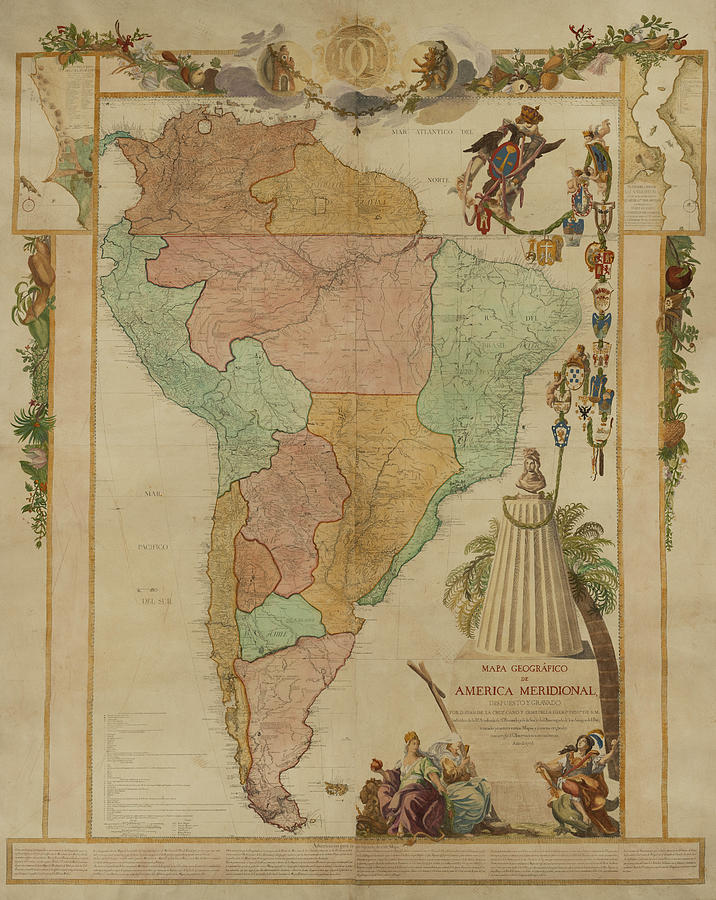
Español: Mapa de ubicación del Virreinato del Perú (territorio inicial (1542) y final (1810) de iure) English: Locator map of the Viceroyalty of Peru (initial (1542) and final (1810) de jure territory). |
| Daatum | (UTC) |
| Quejn |
|
| Urhéwer | Shadowxfox |
.jpg)
Lizenz
Diese Datei ist unter der Creative-Commons-Lizenz „Namensnennung – Weitergabe unter gleichen Bedingungen 3.0 nicht portiert“ lizenziert.
- Dieses Werk darf von dir
- vabroatt wern – vafüfötigt, vabroatt und éffantlich zuegénglich gmocht wern.
- neu zusammengestellt werden – abgewandelt und bearbeitet werden
- Zu den folgenden Bedingungen:
- Nåmansnénnung – Du musst angemessene Urheber- und Rechteangaben machen, einen Link zur Lizenz beifügen und angeben, ob Änderungen vorgenommen wurden. Diese Angaben dürfen in jeder angemessenen Art und Weise gemacht werden, allerdings nicht so, dass der Eindruck entsteht, der Lizenzgeber unterstütze gerade dich oder deine Nutzung besonders.
- Weidergob unter gleiche Bedingungan – Wenn du das Material wiedermischst, transformierst oder darauf aufbaust, musst du deine Beiträge unter der gleichen oder einer kompatiblen Lizenz wie das Original verbreiten.
Dateiversiona
Wensd auf an Zeitpunkt klickst, nacha konst a friaane Version lodn.
| Version vom | Vorschaubuidl | Dimensióna | Nutzer | Kommentar | |
|---|---|---|---|---|---|
| aktuell | 18:47, 22. Jén. 2024 | | 3.121 × 1.586 (1,67 MB) | Janitoalevic | Reverted to version as of 16:41, 18 January 2024 (UTC) En el mapa se muestran territorios de iure, la Amazonía por ejemplo, no se ocupó de facto, mismo caso con la Patagonia. |
| 21:41, 20. Jén. 2024 |  | 3.121 × 1.586 (1,67 MB) | ULIFOX 3XX | Reverted to version as of 04:37, 5 January 2024 (UTC) Si no fue 'De facto' parte del territorio de la Capitanía General de Chile, porque en la practica no fue parte del Virreinato | |
| 18:41, 18. Jén. 2024 |  | 3.121 × 1.586 (1,67 MB) | Janitoalevic | Reverted to version as of 01:41, 16 August 2023 (UTC) La Patagonia pertenecía de iure a a Chile y por ende virreinato del Perú. También los territorios de la Amazonía se encontraban bajo dominio de iure. | |
| 06:37, 5. Jén. 2024 |  | 3.121 × 1.586 (1,67 MB) | ULIFOX 3XX | El Virreinato del Perú nunca tuvo la patagonia como territorio inicial. La Patagonia fue adquirida por Chile y Argentina (ya independizados) despues de 1880 | |
| 03:41, 16. Aug. 2023 |  | 3.121 × 1.586 (1,67 MB) | Janitoalevic | En verde claro van los territorios que dejaron de ser del virreinato del Perú con las reformas borbónicas. | |
| 11:24, 4. Mai 2023 |  | 3.121 × 1.586 (1,67 MB) | Durero | Los territorios que el virreinato nunca controló de forma efectivo van en verde claro | |
| 18:04, 14. Few. 2023 |  | 3.121 × 1.586 (1,67 MB) | Janitoalevic | Reverted to version as of 03:20, 29 December 2022 (UTC) | |
| 18:08, 19. Jén. 2023 |  | 3.121 × 1.586 (1,67 MB) | Durero | Reverted to version as of 21:41, 12 December 2022 (UTC) | |
| 05:20, 29. Dez. 2022 |  | 3.121 × 1.586 (1,67 MB) | Janitoalevic | Fuente: 1 2 [https://es.wikipedia.org/wiki/Fronteras_de_Chile#cite_note-HistoriaDeLasFronteras-13] | |
| 23:41, 12. Dez. 2022 |  | 3.121 × 1.586 (1,67 MB) | Echando una mano | Reverted to version as of 12:20, 7 September 2022 (UTC): no se corresponde con la realidad. |
.jpg)
Dateivawendung
Seitn wo de Datei nutzn:
Globale Dateinutzung
D'noochéfóiganden åndern Wikis vawénden dé Datei:
- Vawendung af ar.wikipedia.org
- Vawendung af ast.wikipedia.org
- Vawendung af be.wikipedia.org
- Vawendung af bg.wikipedia.org
- Vawendung af ca.wikipedia.org
- Vawendung af cs.wikipedia.org
- Vawendung af cy.wikipedia.org
- Vawendung af da.wikipedia.org
- Vawendung af en.wikipedia.org
- Vawendung af es.wikipedia.org
- Historia universal
- Virreinato del Perú
- Imperio español
- Conquista del Imperio incaico
- Hipólito Francisco de Villegas
- Tacna, Arica y Tarapacá hasta 1929
- Organización territorial del virreinato del Perú
- Pedro Álvarez Holguín
- Miguel Mariano de Villegas
- Juan de Lacoizqueta
- Manuel Maciel y Cabral de Alpoin
- Vawendung af et.wikipedia.org
- Vawendung af eu.wikipedia.org
- Vawendung af fa.wikipedia.org
- Vawendung af fr.wikipedia.org
- Vawendung af he.wikipedia.org
- Vawendung af ia.wikipedia.org
- Vawendung af id.wikipedia.org
- Vawendung af it.wikipedia.org
- Vawendung af ja.wikipedia.org
- Vawendung af ka.wikipedia.org
- Vawendung af ko.wikipedia.org
- Vawendung af la.wikipedia.org
- Vawendung af lt.wikipedia.org
- Vawendung af mk.wikipedia.org
- Vawendung af mt.wikipedia.org
- Vawendung af nl.wikipedia.org
- Vawendung af no.wikipedia.org
- Vawendung af pl.wikipedia.org
- Vawendung af pt.wikipedia.org
- Vawendung af qu.wikipedia.org
- Vawendung af ro.wikipedia.org
- Vawendung af ru.wikipedia.org
- Vawendung af simple.wikipedia.org
- Vawendung af sk.wikipedia.org
- Vawendung af sr.wikipedia.org
Weitere globale Verwendungen dieser Datei anschauen.