Datei:Relief Map of Czech Republic.png

Gress dea Voaschau: 800 × 486 Pixel Weitere Auflésungan: 320 × 195 Pixel | 640 × 389 Pixel | 1.000 × 608 Pixel.
Version in hechara Auflesung (1.000 × 608 Pixel, Dateigress: 866 KB, MIME-Typ: image/png)
Bschreiwung
| Bschreiwung |
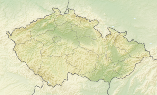
English: Relief map of the Czech Republic
Equirectangular projection, N/S stretching 150 %. Geographic limits of the map:
|
| Daatum | |
| Quejn |
|
| Urhéwer | derivative work Виктор_В |
Lizenz
Diese Datei ist unter der Creative-Commons-Lizenz „Namensnennung – Weitergabe unter gleichen Bedingungen 3.0 nicht portiert“ lizenziert.
- Dieses Werk darf von dir
- vabroatt wern – vafüfötigt, vabroatt und éffantlich zuegénglich gmocht wern.
- neu zusammengestellt werden – abgewandelt und bearbeitet werden
- Zu den folgenden Bedingungen:
- Nåmansnénnung – Du musst angemessene Urheber- und Rechteangaben machen, einen Link zur Lizenz beifügen und angeben, ob Änderungen vorgenommen wurden. Diese Angaben dürfen in jeder angemessenen Art und Weise gemacht werden, allerdings nicht so, dass der Eindruck entsteht, der Lizenzgeber unterstütze gerade dich oder deine Nutzung besonders.
- Weidergob unter gleiche Bedingungan – Wenn du das Material wiedermischst, transformierst oder darauf aufbaust, musst du deine Beiträge unter der gleichen oder einer kompatiblen Lizenz wie das Original verbreiten.
Dateiversiona
Wensd auf an Zeitpunkt klickst, nacha konst a friaane Version lodn.
| Version vom | Vorschaubuidl | Dimensióna | Nutzer | Kommentar | |
|---|---|---|---|---|---|
| aktuell | 10:37, 11. Jén. 2021 | | 1.000 × 608 (866 KB) | ThecentreCZ | Reverted to version as of 11:53, 28 August 2010 (UTC) V Ústavním pořádku České republiky nemají zemské hranice žádné ukotvení a jsou jen přežitkem |
| 00:48, 11. Jén. 2021 |  | 1.000 × 608 (780 KB) | Osidor | přidány zemské hranice (důvod: na mapě jsou užitečné nejméně stejně jako ty krajské [spíše však více]) | |
| 13:53, 28. Aug. 2010 |  | 1.000 × 608 (866 KB) | Виктор В | == {{int:filedesc}} == {{Information |Description={{en|Location map of the Czech Republic}} Equirectangular projection, N/S stretching 150 %. Geographic limits of the map: * N: 51.3° N * S: 48.3° N * W: 11.8° E * O: 19.2° |
Dateivawendung
Seitn wo de Datei nutzn:
Globale Dateinutzung
D'noochéfóiganden åndern Wikis vawénden dé Datei:
- Vawendung af als.wikipedia.org
- Vawendung af arz.wikipedia.org
- Vawendung af ast.wikipedia.org
- Vawendung af azb.wikipedia.org
- Vawendung af az.wikipedia.org
- Vawendung af ba.wikipedia.org
- Vawendung af be-tarask.wikipedia.org
- Vawendung af be.wikipedia.org
- Vawendung af bg.wikipedia.org
Weitere globale Verwendungen dieser Datei anschauen.