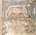
Datei:Shimabara-Battle-Map-c17th-century.png

Gress dea Voaschau: 614 × 600 Pixel Weitere Auflésungan: 246 × 240 Pixel | 491 × 480 Pixel | 786 × 768 Pixel | 1.048 × 1.024 Pixel | 2.097 × 2.048 Pixel | 3.195 × 3.121 Pixel.
Version in hechara Auflesung (3.195 × 3.121 Pixel, Dateigress: 16,15 MB, MIME-Typ: image/png)
Dateiversiona
Wensd auf an Zeitpunkt klickst, nacha konst a friaane Version lodn.
| Version vom | Vorschaubuidl | Dimensióna | Nutzer | Kommentar | |
|---|---|---|---|---|---|
| aktuell | 15:22, 3. Dez. 2021 |  | 3.195 × 3.121 (16,15 MB) | Artanisen | Uploaded a work by Unknown (created circa 17th century) from Yanagawa Ancient Archives - https://www.city.yanagawa.fukuoka.jp/blog-buka/2020/_7900/_7933.html with UploadWizard |
Dateivawendung
Seitn wo de Datei nutzn:
Globale Dateinutzung
D'noochéfóiganden åndern Wikis vawénden dé Datei:
- Vawendung af ar.wikipedia.org
- Vawendung af azb.wikipedia.org
- Vawendung af ca.wikipedia.org
- Vawendung af de.wikipedia.org
- Vawendung af en.wikipedia.org
- Vawendung af es.wikipedia.org
- Vawendung af fr.wikipedia.org
- Vawendung af he.wikipedia.org
- Vawendung af hu.wikipedia.org
- Vawendung af id.wikipedia.org
- Vawendung af it.wikipedia.org
- Vawendung af ja.wikipedia.org
- Vawendung af lt.wikipedia.org
- Vawendung af no.wikipedia.org
- Vawendung af oc.wikipedia.org
- Vawendung af pl.wikipedia.org
- Vawendung af pt.wikipedia.org
- Vawendung af ro.wikipedia.org
- Vawendung af ru.wikipedia.org
- Vawendung af sv.wikipedia.org
- Vawendung af th.wikipedia.org
- Vawendung af tr.wikipedia.org
- Vawendung af vi.wikipedia.org
- Vawendung af www.wikidata.org
- Vawendung af zh.wikipedia.org