Datei:Stryi and Upper Dneistr Rivers.PNG

Version in hechara Auflesung(631 × 648 Pixel, Dateigress: 63 KB, MIME-Typ: image/png)

De Datei kimpt vo Wikimedia Commons. De Beschreibung vo da Dateibschreibungsseitn wead untn ozoagt.

Bschreiwung

Bschreiwung
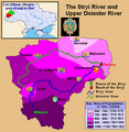
English: This is a map showing the Upper Dniestr River Basin, including its main tributary, the Stryi River, in the southwestern half of the Lviv Oblast in western Ukraine. It also shows the average annual precipitation by millimeters and inches for the region, and places the administrative centers of each of the raions in this area on the map. It includes and inset indicating where this is in relation to the rest of Ukraine, and provides the names of the closest villages to the Stryi River's head and mouth. I created this map, using Microsoft Paint, version 7.0, and borrowing data from Google Earth, and the 21st European Regional Conference 2005 - 15-19 May 2005 - Frankfurt (Oder) and Slubice - Germany and Poland report on "Floods Modeling in the Upper Dnister River Valley", by Ivan Kovalchuk, Andriy Mykhnovych, Volker Ehlert, Jörg Steidl, in conjunction with the Leibniz Centre for Agricultural Landscape Research (ZALF), Germany, and held at the Ivan Franko National University of L’viv, Ukraine, page4. URL: http://www.zalf.de/icid/ICID_ERC2005/HTML/ERC2005PDF/Topic_2/Kovalchuk.pdf
Daatum 10. Fewer 2010 (Original-Hochladedatum)
Quejn Transferred from en.wikipedia to Commons by SreeBot.
Urhéwer Saukkomies in der Wikipedia auf Englisch

Lizenz

Public domain Dieses Werk wurde von seinem Urheber Saukkomies in der Wikipedia auf Englisch als gemeinfrei veröffentlicht. Dies gilt weltweit.
In manchen Staaten könnte dies rechtlich nicht möglich sein. Sofern dies der Fall ist:
Saukkomies gewährt jedem das bedingungslose Recht, dieses Werk für jedweden Zweck zu nutzen, es sei denn, Bedingungen sind gesetzlich erforderlich.

Ursprüngliches Datei-Logbuch

De oaginale Dateibeschraibungseitn woa do. Imma, wenn jetzt Nutzanama gmoand san, hot des mit en.wikipedia zum doa.

Upload date | User | Bytes | Dimensions | Comment

  • 2010-02-10 01:12 (UTC) | Saukkomies | 64995 (bytes) | 631×648 | I created this map, using Microsoft Paint, version 7.0, and borrowing data from Google Earth, and the 21st European Regional Conference 2005 - 15-19 May 2005 - Frankfurt (Oder) and Slubice - Germany and Poland report on "Floods Modeling in the Upper Dnist

Kurzbeschreibungen

Ergänze eine einzeilige Erklärung, was diese Datei darstellt.

In dieser Datei abgebildete Objekte

Motiv Deutsch

Dateiversiona

Wensd auf an Zeitpunkt klickst, nacha konst a friaane Version lodn.

Version vomVorschaubuidlDimensiónaNutzerKommentar
aktuell19:36, 18. Sep. 2011Vuaschaubuid fiad Version vom 19:36, 18. Sep. 2011, 19:36 Uhr631 × 648 (63 KB)SreeBot(Original text) : I created this map, using Microsoft Paint, version 7.0, and borrowing data from Google Earth, and the 21st European Regional Conference 2005 - 15-19 May 2005 - Frankfurt (Oder) and Slubice - Germany and Poland report on "Floods Modeling

Seitn wo de Datei nutzn:

Globale Dateinutzung

D'noochéfóiganden åndern Wikis vawénden dé Datei: