Kanton Brouvelieures
Da Kanton Brouvelieures woa bis 2015 a franzesischa Kanton im Arrondissement Saint-Dié-des-Vosges, im Département Vosges und in da Region Lothringen; sei Haptort woa Brouvelieures. Letzda Vatreta im Generoirod vom Départements woa vo 1998 bis 2015 Étienne Pourcher (PS).
| Ehemoliga Kanton Brouvelieures | |
|---|---|
| Region | Lothringen |
| Département | Vosges |
| Arrondissement | Saint-Dié-des-Vosges |
| Haptoat | Brouvelieures |
| Aflesungsdatum | 29. Meaz 2015 |
| Eihwohna | 2.677 (1. Jén. 2012) |
| Dichtn | 30 Eihw./km² |
| Flächn | 88,85 km² |
| Gmoana | 10 |
| INSEE-Code | 8802 |
| Koordinatn | Koordinaten fehlen! Hilf mit.
Koordinaten fehlen! Hilf mit. |
| Häh | |
Log
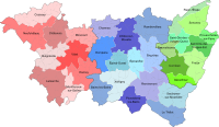
WerkelnDa Kanton is im Ostn vom Département Vosges gleng.
-
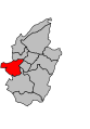 Log vom Kanton Brouvelieures innahoib vom Arrondissements Saint-Dié-des-Vosges
 -
 Log vom Kanton Brouvelieures innahoib vom Département Vosges


Gmoana
WerkelnDa Kanton hod aus zehn Gmoana bstondn:
| Gmoa | Eihwohna Joar | Fläch km² | Bevejkarungsdichtn | Code INSEE | Postleitzoih |
|---|---|---|---|---|---|
| Belmont-sur-Buttant | 288 (2013) | 8,46 | 34 Eihw./km² | 88050 | 88600 |
| Biffontaine | 426 (2013) | 8,88 | 48 Eihw./km² | 88059 | 88430 |
| Bois-de-Champ | 118 (2013) | 17,69 | 7 Eihw./km² | 88064 | 88600 |
| Brouvelieures | 470 (2013) | 7,36 | 64 Eihw./km² | 88076 | 88600 |
| Domfaing | 227 (2013) | 3,9 | 58 Eihw./km² | 88145 | 88600 |
| Fremifontaine | 480 (2013) | 9,56 | 50 Eihw./km² | 88184 | 88600 |
| Mortagne | 159 (2013) | 22,2 | 7 Eihw./km² | 88315 | 88600 |
| Les Poulières | 256 (2013) | 2,98 | 86 Eihw./km² | 88356 | 88600 |
| Les Rouges-Eaux | 87 (2013) | 5,9 | 15 Eihw./km² | 88398 | 88600 |
| Vervezelle | 130 (2013) | 1,92 | 68 Eihw./km² | 88502 | 88600 |
Bevejkarungsentwicklung
Werkeln| 1962 | 1968 | 1975 | 1982 | 1990 | 1999 | 2006 | 2012 |
|---|---|---|---|---|---|---|---|
| 2426 | 2462 | 2356 | 2383 | 2356 | 2381 | 2541 | 2677 |
Koordinaten: 48° 14′ N, 6° 43′ O