Datei:Peten Map v3 May archaeological sites.gif

Gress dea Voaschau: 684 × 599 Pixel Weitere Auflésungan: 274 × 240 Pixel | 548 × 480 Pixel | 979 × 858 Pixel.
Version in hechara Auflesung (979 × 858 Pixel, Dateigress: 47 KB, MIME-Typ: image/gif)
Bschreiwung
| Bschreiwung |
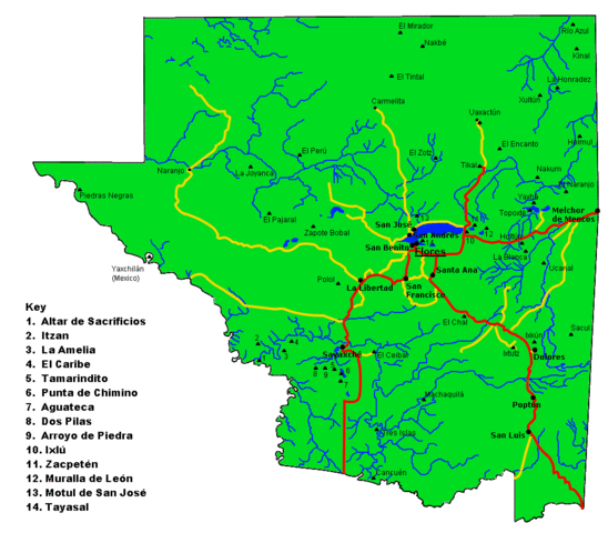
English: Map of the Maya archaeological sites in El Petén Department.
Español: Mapa del departamento guatemalteco de Petén, con los más importantes sitios arqueológicos Mayas. |
| Daatum | |
| Quejn | Eigenes Werk |
| Urhéwer | Simon Burchell |
Lizenz
Diese Datei ist unter der Creative-Commons-Lizenz „Namensnennung – Weitergabe unter gleichen Bedingungen 3.0 nicht portiert“ lizenziert.
- Dieses Werk darf von dir
- vabroatt wern – vafüfötigt, vabroatt und éffantlich zuegénglich gmocht wern.
- neu zusammengestellt werden – abgewandelt und bearbeitet werden
- Zu den folgenden Bedingungen:
- Nåmansnénnung – Du musst angemessene Urheber- und Rechteangaben machen, einen Link zur Lizenz beifügen und angeben, ob Änderungen vorgenommen wurden. Diese Angaben dürfen in jeder angemessenen Art und Weise gemacht werden, allerdings nicht so, dass der Eindruck entsteht, der Lizenzgeber unterstütze gerade dich oder deine Nutzung besonders.
- Weidergob unter gleiche Bedingungan – Wenn du das Material wiedermischst, transformierst oder darauf aufbaust, musst du deine Beiträge unter der gleichen oder einer kompatiblen Lizenz wie das Original verbreiten.
Dateiversiona
Wensd auf an Zeitpunkt klickst, nacha konst a friaane Version lodn.
| Version vom | Vorschaubuidl | Dimensióna | Nutzer | Kommentar | |
|---|---|---|---|---|---|
| aktuell | 14:38, 19. Nóv. 2010 | | 979 × 858 (47 KB) | Simon Burchell | Remove stray ruins symbols that crept in during last edit. |
| 14:31, 19. Nóv. 2010 |  | 979 × 858 (47 KB) | Simon Burchell | Added some more archaeological sites. | |
| 13:14, 19. Nóv. 2010 |  | 979 × 858 (46 KB) | Simon Burchell | Correct location of La Blanca, added location of Ucanal and moved Holtun text. | |
| 13:19, 18. Nóv. 2010 |  | 979 × 858 (46 KB) | Simon Burchell | {{Information |Description={{en|1=Map of the Peten department of Guatemala with important Maya archaeological sites marked.}} {{es|1=Mapa del departamento guatemalteco de Petén, con los más importantes sitios arqueológicos mayas.}} |Source={{own}} |Aut |
Dateivawendung
Seitn wo de Datei nutzn:
Globale Dateinutzung
D'noochéfóiganden åndern Wikis vawénden dé Datei:
- Vawendung af bn.wikipedia.org
- Vawendung af ca.wikipedia.org
- Vawendung af de.wikivoyage.org
- Vawendung af el.wikipedia.org
- Vawendung af en.wikipedia.org
- Vawendung af eo.wikipedia.org
- Vawendung af es.wikipedia.org
- Vawendung af fr.wikipedia.org
- Vawendung af hy.wikipedia.org
- Vawendung af it.wikipedia.org
- Vawendung af ja.wikipedia.org
- Vawendung af zh.wikipedia.org