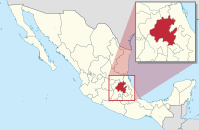
Hidalgo (Bundesstoot)
Hidalgo is a zentroia Bundesstoot vo Mexiko (1869 buidd), neadli vo da Haptstod gleng. Ea is bnennd noch Miguel Hidalgo, dea mid seim Grito de Dolores an Unobhengigkeitskompf in Mexiko iniziiad ghod hod. Ea hod 20.813 km² und ca. 2,7 Mio. Eihwohna (Stond Zensus: 2010. Haptstod is Pachuca de Soto. Administrativ untagliedad is da Bundesstoot in 84 Municipios.
| Hidalgo | ||
|---|---|---|
|
 | |
| Hauptstod | Pachuca de Soto | |
| Fläch | 20.813 km² (Rang 26) | |
| Eiwohna | 2.665.018 (Rang 17) | |
| Dichtn | 128 Einwohner pro km² (Zensus 2010) | |
| Gouverneur | José Francisco Olvera Ruiz (PRI) (2011–2015) | |
| Bundesobgeoadnete | PRI = 7 (Insgesamt 7) | |
| Senatoan | PRI = 2 PAN = 1 | |
| ISO 3166-2 | MX-HID | |
| Postobkiazung | Hgo. | |
| Hoamseitn | www.hidalgo.gob.mx | |
De briahmdsde Attrakzion van Stoot is de Ruinastätte Tula, vo dea ma onimmd, se sei de Haptstod vo de Toltekn gwesn.
De Wiatschoft is haptsechli duach'n Beagbau (Süwa, Goid, Blei, Kupfa, Zink) und de Landwiatschoft bstimmd.
Bevejkarungsentwicklung
Werkeln| Joar | Eihwohnazoih |
|---|---|
| 1950 | 850.394 |
| 1960 | 994.598 |
| 1970 | 1.193.845 |
| 1980 | 1.547.493 |
| 1990 | 1.888.366 |
| 1995 | 2.112.473 |
| 2000 | 2.235.591 |
| 2005 | 2.345.514 |
| 2010 | 2.665.018 |
| 2015 | 2.858.359 |
Im Netz
Werkeln- Website van Bundesstoot (spanisch)
Koordinaten: 20° 29′ N, 98° 52′ W
