Studley (Warwickshire)
Studley is a Doaf in da englischn Grofschoft Warwickshire. Se grenzd im Noadwestn direkt on Redditch in da Grofschoft Worcestershire.
| Studley | |||
|---|---|---|---|
| |||
| Koordinaten | 52° 16′ N, 1° 53′ W | ||
| Eihwohna | 6.624 | ||
| Verwaltung | |||
| Post town | STUDLEY | ||
| PLZ | B80 | ||
| Vorwoi | 01527 | ||
| Landestei | England | ||
| Region | West Midlands | ||
| Shire county | Warwickshire | ||
| District | Stratford-on-Avon | ||
| ONS-Code | SP075635 | ||
| Hoamseitn: studleyparishcouncil.org.uk | |||
In je 20 bis 30 Kilometa Entfeanung findn se: Birmingham im Noadn, Warwick im Ostn, Stratford-upon-Avon im Sidn und Worcester im Westn.
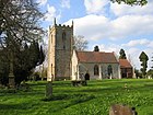
Im Ort bfindd se de Church of the Nativity of the Blessed Virgin Mary (St. Mariä Gebuatskiach), de Little Zoar Chapel vo de strenga Baptistn und oa Kilometa weida sidli's historische Kiachngebaide St Leonard.
Vo 1898 bis 1969 hod da Ort's Studley Horticultural & Agricultural College for Women, a Hauswiatschofts- und Goatnbauschui, bheabeagd, de ob 1903 im Studley Castle residiad hod.
Berihmtheitn
Werkeln- Dion Fortune (1890–1946), Okkultistin
- Andy Smith (* 1967), Dartspuia
Im Netz
Werkeln Commons: Studley – Sammlung vo Buidl, Videos und Audiodateien


