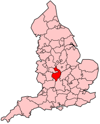
Warwickshire
| Der Artikl is im Dialekt Obaboarisch gschriem worn. |
| Warwickshire | |
|---|---|

| |
| Geographie | |
| Status: | Zeremonielle und Vawoitungsgrofschoft |
| Region: | West Midlands |
| Flächn: | 1.975 km² |
| Verwoitungssitz: | Warwick |
| ISO 3166-2: | GB-WAR |
| Demographie | |
| Bevejkarung: - Gsamt (2012) - Dichtn: |
547.947 277/ km² |
| Distrikte | |
 | |
Warwickshire is a Grofschoft im mittlan England mit ara Flächn vo 1.975 km² und 547.947 Einwohna (Stand 2012). De Haptstod is Warwick. An Warwickshire grenzn de Grafschoftn Staffordshire und Leicestershire im Nordn, Northamptonshire im Ostn, Oxfordshire und Gloucestershire im Sidn und Worcestershire im Westn.
Warwickshire is in de Distrikte North Warwickshire, Nuneaton and Bedworth, Rugby, Stratford-on-Avon und Warwick unterteit. Friaha hom a Coventry, Solihull und Birmingham za Warwickshire ghead. Owa de san 1974 Tei vom Metropolitan County West Midlands worn.
De gresstn Städt san (Stand 2004): Nuneaton (77.500 Enwohna), Rugby (62.100), Leamington Spa (42.300) und Bedworth (32.500).
Städt
Werkeln
|
|
Berihmdheitn aus Warwickshire
Werkeln- William Shakespeare aus Stratford-upon-Avon
- George Eliot aus Nuneaton
- Rupert Brooke aus Rugby
- J. R. R. Tolkien hod ois Kind in Sarehole glebt
Sengswiadigkeitn
Werkeln- Arbury Hall
- Da Fluss Avon
- Coombe Abbey
- Coventry-Kanal
- Draycote Water
- Grand-Union-Kanal
- Kenilworth Castle
- Kingsbury Water Park
- Ladywalk Reserve
- Mary Ardens House
- Oxford-Kanal
- Rollright Stones
- Rugby School
- Warwick Castle