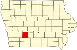
Adair County, Iowa
| Der Artikl is im Dialekt Westmiddlboarisch (Bayern) gschriem worn. |
Adair County[2] is a County im Bundesstoot Iowa in da USA. Es hod 7682 Eihwohna. Da Sitz vo da Vawoitung is Greenfield.

| Vawoitung | |
|---|---|
| US-Bundesstoot: | Iowa |
| Sitz vo da Vawoitung: | Greenfield |
| Adress vom Vawoitungssitz: |
County Courthouse 400 Public Square Greenfield, IA 50849-1259 |
| Grindung: | 1851 |
| Buidt aus: | Pottawattamie County |
| Vuawoi: | 001 641 |
| Demographie | |
| Eihwohna: | 7682 (2010) |
| Dichtn: | 5,2 Eihwohna/km² |
| Eadkund | |
| Flächn gesamt: | 1.477 km² |
| Wossaflächn: | 3 km² |
| Koartn | |
 | |
| Hoamseitn: www.adaircountyiowa.org | |


Geografie
WerkelnDes County liegt im middlan Sidwestn vo Iowa und hod a Flächn vo 1477 Quadratkilometa, wovo drei Quadratkilometa Wossaflächn san.
Ans Adair County grenzn foignde Nochboacountys:
| Audubon County | Guthrie County | |
| Cass County | Madison County | |
| Adams County | Union County |
Gmoana
Werkeln- Adair
- Bridgewater
- Casey
- Fontanelle
- Greenfield
- Orient
- Stuart
- Arbor Hill
- Berea
- Canby
- Fisk
- Hebron
- Howe
- North Branch
- Rosserdale
- Stanzel
- Zion
Beleg
Werkeln- ↑ Auszug aus dem National Register of Historic Places - Nr. 81000224 Obgruaf am 17. Septemba 2014
- ↑ Adair County im Geographic Names Information System vom United States Geological Survey
|
Countys in Iowa
|
Koordinaten: 41° 20′ N, 94° 28′ W